We started down
Highway 21 towards Boise
Fall color is coming
to Boise
We traveled south on
Highway 95
I planned our route on my computer, planning to camp along
the highway about 15 miles north of McDermitt NV. I found an area that was on
BLM land, and yet not too far off the highway. You never know what you are
going to find. Not everything that you find on the computer actually works out
in real life. This time I lucked out. It would have been nicer if the wind had ever
stopped. Even the cats weren’t that
interested in going outside.
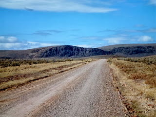
Heading down a small
dirt road, looking for camping
There weren’t any
trees to park behind, so we chose to park by some BLM equipment, feeling that
people would leave the rig alone if it was near government equipment.
Wednesday we woke up to an even windier day. It would rip the doors of the RV and trailer
right out of our hands. But we went
riding anyway. It was in the 40’s, so
not real cold, but the wind chill factor made it feel like 25. We started out following a track I made that
would take us to intersect the TAT, the trail we will ride next year. Unlike the routes I made for the Pahsimeroi,
the roads on my maps are not all there anymore.
Fire has come through and obliterated many of them. So we had to take the highway a bit, until I
found a road that would work.
We started out across
the desert
The clouds were
pretty low
Obviously no cows in
this area, there was still grass left to turn orange and contribute to the
color
We found these hot
springs
This was a bath house
in the truest manner. It was a covered
pool.
It was a very hot
fast stream
When we saw the hot springs
from down the road we first thought that the steam was the dust from a car coming our way, then I thought
maybe dust devils.
Nope, it was a major
hot springs.
It bubbles from the
ground in many places, all of them very hot. This resort may have been abandoned due to the water getting too hot to get into. We couldn't find a cold water source to cool it down.
Checking out the old
building
It really was a pool
From there we spent some time trying to get to where the TAT
would cross our route. We followed cow trails and jeep roads across the desert
until we got tired of crossing private land.
We then went really cross country to get to the Cordero Mine Road. Here we picked up the TAT. It was paved, but we soon left that to play
in the dirt.
We started on a big
car road
Went by some cool
looking rocks
It was a long and
winding road….
Disaster Peak is on
the right, Little Peak on the left
We came pretty close
to Little Peak
We went down China
Creek, finding a place for lunch. This
area was part of a large fire area, looks like maybe 5 years ago
This old house was up
Kings River
Along Kings River
On Log Cabin Creek
We continued following the TAT until we got to Denio
Junction. Not much of a town, just a
couple of homes. This put us on Highway
140. We went north to Cottonwood Creek
Road. Here we found more private land,
so we abandoned our planned route and after talking to a local and checking out
his advice on my laptop (that I carried in my backpack for just this reason) we
headed up the Whitehorse Ranch Road.
This was a big car road. It was
now after 4 PM and we wished we could find gas somewhere, just in case, but no
such luck. At one stop I decided to try
to get my GPS to plan us a route back to camp, as I couldn’t figure out how to
make some roads connect. Sure enough
(love my Garmin!!) I put in McDermitt and it created a route!
The long, very straight, White Horse
Cutoff road saved us about 20 miles of cold highway riding
The route then had us turn left on the Oregon Canyon Road,
which was part of my original return route.
This brought us to the highway, right across from where we were parked,
how cool was that. Our spot looked a
little different, 3 trucks and trailers had come to camp near us, because they
were white we saw them before our own rig, but we knew we were home. It was just before 6 PM, the sun was still up
and we had put in 176 miles. We got to
pre-ride some of next year’s route, and didn’t find anything real tough or
scary. When someone else plans a route,
you never know what you are going to find.
I was happy with what we found.
Thursday was a travel day; we got to our new home in Reno in
the afternoon.
We passed by Sawtooth
Mountain
We saw this strange
cloud, maybe it’s a fire
We will be in Reno until the end of December when we will
begin our next adventure, traveling to Daytona Beach Florida for bike
week. I may not post much before we
leave as we will be working and don’t know how much riding we will be doing. But
if we ride, I’ll post. I promise!


No comments:
Post a Comment